Saturday 31 October 2009

Last Days

So, following our trek we still had one week left to spend in this beautiful mountain kingdom. So let me introduce to a sport I like to call "Extreme uphill mountain bike pushing." Just incase someone tries to catch you out I should warn you that it can also be known as just "mountain biking in Nepal" and it is a bad idea. I know this because we decided to spend a few days of our last week chilling out in a small village called Astam where Purna (who had organised our trek) and his 2 brothers was building a small eco-village on some of his Father's land where they grew up. We decided to try and cycle there, Dave beinga keen biker and us thinking it would be fun and give us a bit more independence round the village. We quickly realised that this was no Cambridge, taking 3.5 hours to complete Purna's alleged 1 hour ride!


The village was a stunning spot though, at the top of a hill in between Pokhara and Annapurna the views of the mountains were fantastic. The building on the right in this picture is where we slept and just outside there was a hammock where I spent many happy hours reading, staring at mountains and generally chilling out :) The shack in the foreground was the kitchen since the building of the eco-village was not quite complete! Here a great guy called Ganesh spent endless energy cooking Dal Bhat and pancakes over an open fire inside. One night we celebrated with a special meal of dal bhat with chicken curry. For the first time in my life I saw 700 rupees turn into a live chicken which was beheaded with a heavy knife, twitched for a long time, and was then plucked, washed and butchered (bones included) all in this little shack! A few hours later there was chicken curry for dinner. Also straight from the source came the milk, which was milked straight from their 2 cows before breakfast, the honey which came from alocal man who collected honey from the source and the veg which was all grown on a small plot in the eco-village. It was fascinating to see this way of living, so much more complete than a trip to sainsbury. At the end we thoroughly enjoyed our cycle back down a good 750m or dirt track and had a few less locals laughing at our impractical machines!

The next day we started to retrace our steps first back to Kathmandu where we had just a couple of days left to spend doing a bit more sight-seeing and present shopping before going our seperate ways. We took a trip over to Patan, a town just a few kilometers from Kathmandu with the greatest density of temples in the Kathmandu valley. The Patan museum was also full of interesting explanations of the hinduism and buddhism as practiced in Nepal and all the complex relations between the two, it had been our only museum trip in 5 weeks and we were probably due one! We also visited a couple of large buddhist stupas packed with Tibetans who fled to Nepal after the Chinese invasion in 1959 and now form large communities in the mountain areas and the capital. On thursday morning we boarded planes to return to Delhi and from there both flew to Bombay on seperate flights from whence we parted ways, Dave to England and myself to Sydney where I arrived on saturday night.

Wednesday 21 October 2009

From Muktinath back to Pokhara (days 11-16)


So...the final 5 days of the trek remain, and I will whizz through them in pretty much the same wy that we seemed to! In Muktinath, after nearly 11 hours of walking I had my first REALLY hot shower since starting this trip. It was fantastic. For moments it was actually scolding hot! For a comparison, at one of the places we stayed I was parceled off with a bucket of hot water and a scoop to a small wooden hut on stilts, everywhere else there have just been very cold showers.
Later in the evening we also visited the Muktinath temple, a place of pilgrimage for many Hindus. It is significant because there they found a natural gas from the ground, hot stones and water, which unites air, water and fire in one place.

From Muktinath we carried on the steep descent to Marpha. We passed through the Nepali desert, which is in the rain shadow of the mountains and stays dry even in the rainy season. The rivalley was cut away dramatically with cliffs on either side giving it the same dramatic look as the Grand Canyon, carved out of red rock. It was tough going along the valley bottom because the steep cliffs acted as a wind funnel an we blown backwards by air and dust. The trail was also a rudimentary jeep track and sometimes jeeps would pass flicking stones out as they went. When we reached Marpha it was like an oasis in the desert. The town was built on a patch of flat land to one side of the river and the wind shadow of anothermountain. It was surrounded by the most green we had seen all day and is the "apple capital of nepal", famed above all for its apple brandy, which of course we were obliged to try.

A couple of days further down we reached the town of Tatopani, which translates literally as Hot Water. The town is famous for its hot springs, although the locals pump the wter into two stone pools to make more space. We spent a relaxing couple of hours resting our aching legs and feet in the pools, in preparation for our final big climb the next day.

The final big climb took us up about 1800m to Ghoripani, it was then just another hours climb up to Poon hill (a 3200m hill) which is famed for its stunning views of the mountains at sunrise. It was another early start, and at 5am of our last day we started the climb up to see the sunrise, along with a trail of so many people the glints of head torches seemed to form a path all the way back down the hill. I really need to put a panorama together to show you, because the top of the hill commanded a 270 degree view across both the Annapurna range and the Dhulagiri ranges, but here is a botch job that my camera has done (don't look to closely, but it gives youthe idea) of the Annapurna range.

We returned to the guest house fpr breakfast and then made a 7 hour hike down hill to Nayapul where our trek ended and we got a taxi back to Pokhara. The final day was spent passing through terraced farmland that looked like it was straight out one of those aerial picture books and waterfalls that looked like they were straight out of Timon and Pumba's paradise in the Lion King. It was both happy and sad to have finished the trek, we were more than happy with some clean clothes, warm showers and a lie in, but it was sad to leave behind such incredible, stunning mountain scenery as we have had the chance to explore.

Thorung La: Passing higher than the Alps (days 5-11)

Luckily on the 5th day the rain stopped. I had woken up early in Tamang (6.15am) in order to check and seeing the windows still rain streaked grumpily snuggled deeper into my sleeping bag. It made me jump when just 10 minutes later our guide came knocking on the door telling us we could see the mountains for the first time and that we would be making the early start that we had agreed on if the weather was good. I leapt out of my sleeping bag in t-shirt and shorts, threw on a coat and flip flops and went in search of the mountains I had almost started to doubt ever seeing. Here is a picture of my first glimps of Monasolu in the early morning from our guest house in Tamang (around 2000m).

The days walking showed us that we come arrived up and out of the valley and the walking was now easy going on a wide path through pine forests that rose gently reminding me uncannily of family strolls in Ashdown forest (the setting of Winnie the Pooh) . Mountains would appear on either side, majestic and astounding, even more impressive for their extra coat of snow and the days were short. We would start early while the skies were clear walk for 3-4 hours and arrive somewhere early enough to get a good room. October is peak season here and the trails were busy, even more so because so many had been held up in the rain, and others with limited time to compete the trek were having to come down because the pass had been closed when they arrived, those who arrived late sometimes could not find space.

On our 7th day we arrivd in Brackha, a small village just 20 minutes short of Manang, the district capital (although still supplied only ny mule train and the occasional helicopter). At 3500m this was the start of Yak territory and a popular place to stop and spent 2 days acclimatising to the high altitude. From here we took 2 trips, one to the Manang view point and the other to ice lake. Here is a photo from the Mananag view back towards Brackha and along the trail we arrived on.

On the second day we decided to take a hike up to Ice Lake, at a height of 4600m which would take us well into the snowline we had been watching for so long. This turned out to be quite an epic undertaking. It was a climb of 1300m, roughly equal to Ben Nevis, but at altitude and much steeper than the way hills are formed at home! We started early, around 7.30 and reached the lake one packet of bisuits and 2 mars bars later at 12.00. The high altitude luckily wasn't making either us of feel ill but it was difficult to reathe enough and I found myself panting after just a few steps and my legs seemed to burn anaerobically however much panting I did. Still, reaching the lake we felt like we had really climbed up into the Himalaya for the first time...here I am on the way back down.

3 days later we reached Thorung Phedi, which is the final camp, at aroind 4400m before crossing the pass. The highest point of the pass is 5416m, higher than the highst of the alps and still a low point here. Here we started at 4am, incase of slow progress or altitude problems and to be sure of reaching the pass early before it gets windy. The climb this time was only 1000m, less than that to the ie lake but the extra 1000m of altitude made it much more difficult. Eating breakfast at 3.30am I felt a little quezy and by this time just looking at a hill I felt out of breath. The first hour of the climp was a constanlt steep scree slope and at the top we had a brief stop. The combination of an early start, an undigested breakfast and a slightly dodgy stomach had left me feeling pretty ill and we took a tea break at "high camp" the last place to top before taking on the pass. The second hour brought us out in to more open terrain with sharp climbs interspersed with flatter ground, but thi alo brought more wind and the temperatures were below anything I had experienced before, the snow on the ground was frozen so solid that our boots made no impact. I was breathing constantly as though I had just done a 2k erg test bd every breath the cold ear burned through my chest. Constantly walking uphill with 4 4 jumpers on, a coat, hat and gloves I was still cold. I was well out of my own temperature guage but a Canadian couple I asked guessed it might be around -10C. Cold. After this the sun started to come up and walking in the sun me and my mars bars gradually started to thaw. At 9.15, 5 hours after starting we reached Thorung La.

The view from the Thorung La was immense. Behind rose the gentle snowy slopes of the way we had come, where many trekkers were still trickling up. On the other side was a surreal window down into the world through the cloud, and across to another mountaing range (the Dhulagiri mountain range) which it felt like we were level with (although realistically we were a a couple of thousand metres lower). This was the way we would decend, down a full 1600m of snow and scree, at one point passing through a smoothed down half-pike of slippery ice until about 6 hours later we reached civilisaion again in the town of Muktinath.

The Start of the Trek (days 1-4)

"It looks like its about to flood" I say to David who nods in agreement.
"Is it about to flood??" I ask our Guide Om (same as Hom in Tibetan chants...meaning good luck, as he continuously tried to persuade us we had) not shading the alarm from my voice.
"Yah, yah" he replied keenly, as he did to 99% of questions asked only once. I frowned from Om, to Dave, to the small hamlet perched right next to the gushing river several hundred feet below us, clearly built on the flood plain. Infact it seemed to me the river in places ran right through the hamlet, creating a small island of guesthouses but it was hard to tell, the rain was heavy enough to make it hazey.

This was our arrival in Tal on the 3rd day of our trek. In Tal it had rained solidly for 5 days and as we sat in the restaurant that night the thundering sound of landslides some in the distance, and some quite close, could be heard as the saturated valley walls gave way. We were concerned for a little while that we had accidently stumbled here in the midsts of the monsoon season, and not the perfect clear skies forecast for Nepal in August. But no, for the Lonely Planet guide to trekking in Nepal confidently stated that a monsoon "was not a continuous downpour" but instead "a considerate rain falling mainly at night." No. We had commenced our trek in something much more formidable than a monsoon.

It was in Tal I also had my first epiphany about life in England. That is that I will nver under-appreciate radiators again. Nor will I take for granted sealed roofs, sealed walls, tumble dryers, warm showers and least of all roads. The first days of our trek involved following the Marsyangdi river up towards its mountain source. The sides of the valley are steep to almost vertical, the path is littered with previous landslides and the path dips and rises steely up and down the valley walls and crossing long swaying bridges from one side to the other in an attempt to find solid enough ground for a trekking trail. Roads here are impossibly out of the question. The villages that litter valley full of farms and guesthouses are supplied by porters and mule trains alone. That means that when we arrived in Tal, following 2 days of heavy rain, we were 3 days walk from anywhere, the electricity was out because of the rain (and anyway supply is far insufficient for the population leading to daily powercuts) and there were no fires because chopping down trees here is a tabboo cause of more landslides (ref. your geography GCSE notes). To compund matters further Tal was full to bursting with trekkers already who had arrived the day before but not been able to move on up because just above Tal a waterfall which crossed the path was too heavy to cross. After much sweet-talking from Om (and of course a little of his good luck) we found a room which dripped on one side and had a fairly wet floor and slightly damp mattress but was otherwise and Ok place to spend a night. From here it was a 5 minute sprint across some mud to a restaurant where we spent our night drinking tea, playing cards, ordering excessive volumes of Dahl Bhat and hoping for the rain stop. The Ukrainians opposite us suggested we also order whisky, I am pretty confident it would have been vodka had that been in stock.

Rather astoundingly, and perhaps also due to the presence of our Om, the next day that black clouds that had boxed us into our deep-valleyed prison gave way to reveal Tal as really quite a beautiful and peaceful place. Breathing many sighs of relief (in part because it was a very steep climb) we carried on up with the valley. At the end we could see a towering snow covered mountain, but on enquiery were told that it was actually just a peak, standing a mere 3500m or so in height. What we had experienced as rain those further up the trail had experienced as snow, and Thorung La, the high point of our trek had become completely impassable, steeped in over a metre of snow. As we made our way onwards we knew that the weather must improve or we would not be able to get through and would instead have to turn and walk for a week back down the way we came. In the mean time though the rain had made the waterfalls and even more impressive sight and here is a picture of just one of the many that we crossed that day on the way from Tal to Tamang. If you peer closely you should be able to just about make out people queuing up to cross.

Saturday 3 October 2009

Kathmandu to Chitwan to Pokhara

I have run out of time to be writing this blog now, and you may well have run out of patience with reading it!

So in brief...

The next day we made our way to Chitwan National Park, first by taxi, then by white water raft (22km) which was alot of fun


Then by the roofrack of a Nepalese bus (which was even more fun) since the buses were all packed out because of the Dashain festival, but Dave has all the photos because by bag was wedged the other end of the roof rack to me. However, I can still impart to you my newfound but nevertheless authoritative wisdom that 21 years of car seats is just not adequate preparation for the glutaneous muscles for spending 2.5 hours sat on a grid of metal bars driving down a pot-holed road.

Then by jeep from the bus stop to our guest house, which was one of the most stunning sunsets I've ever seen and it sillouhetted workers wading home across rivers, water buffalo and paddi fields.

Then we spent a day in Chitwan, which was rather toursit packed but at times stunning. We saw a rhino taking a bath in the river while we were trying to canoe down in a very wobbly hollowed out tree and also a couple of crocks. If you look closesly at the picture you might start to wonder whether those are just clouds of some 8000m peaks in background, I got frequently confused, but often it turned out they were immense snow-covered mountains hundreds of kms away.

From Chitwan we took a 5 hour, extremely sweaty bus to Pokhara where we have now spent 2 days and I will tell you all about it when I get back from the 16 day trek we're starting tomorrow with a Nepalise guide I have just met, sporting a rather funky affro and a book I found that is "Not to be sold outside the Asian subcontinent" that I just had to have! (So far the english have invaded Burma with cannons for no good reason at all)

So until then take care,
Gabi

Around Kathmandu

Namaste!
So I left you last time around midnight in Delhi and now it is 4pm and I am in Pokhara, the second biggest city in Nepal on the edge of Lake Phewa and withing clear sight of the Annapurna region of the himalayas in the clear mornings. The annapurna region contains three of the world's fourteen 8000 metre peaks in it so it is an impressive sight! But more of that after the trek I am starting tomorrow, for now I will fill you in on all the adventures of the journey.

We arrived in Kathmandu on a plane from Delhi full of keen treckers. I was luck enough to bag a window seat and the landscape coming in looked so hilly (I would say mountainous but here that means a whole different thing. I find it similar to talking to Scottish people about rain...our standards just arenb't the same) that I was not sure there could be anywhere flat long enough to buil a runway! But lo and behold we rose up the final peak to cross an impressively large plateau craddled on all sides by 'mountains' and full of Nepal's capital city, Kathmandu (1400m).

We were met (after a condiderable visa faff) by Purna, a friend of a friend I had met in England and who runs a trekking company here and so had organised our programme and he dropped us off at our guest house.


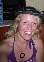
Here is a picture of me at said guest house for 2 reasons:
1) to prove to my Mum I wash clothes
2) because Lou has requested in the comments section more pictures of me*


*If you would like to make a comment (eg. please can we have less pictures of you washing clothes) then please do


The next we took a look around the sites of Kathmadu. I did not have very high expectations as I had never really heard of any but this left be open to being completely blown away! We started off witha trip to the temple, Pashupatinath. In Nepal hinduism and Buddhism mix freely and most temples are devoted to both, this one included although foreigners are not allowed inside the religious buildings they are welcome to takle a look around (for a price).

Here is a picture across the first bridge you come to in the enclosure:


On the left of the river is the main temple building, which was unfortunately shut because it was festival time. On the right is a line of mirror temples, looking in one end you see the same thing reflected over and over. There are litterally hundreds of these small shrines/ temples throughout the complex, each to a different God. On the left, just out of view stands the main temple building. The yellow blob that you can see on the steps of the river is a dead body covered in a golden cloth with insence burning around it. It will stay there for a few hours until all the relatives have come to pay repects and then be burnt on the platform just infront of it. This side of the bridge is reserved for important people and the other side (behind me as I take this picture) were aready burning the bodies of common folk.


As we made our way clockwise around the temple (as is apparently required of hindu custom) we came to a cluster of holy men (sadhus) who were more than happy to pose for a photo for a dew backsheesh. They live in houses partly made out of caves in the rock of the gorge just upstream of the temple and reply on donations and begging to survive.

No one knows exactly how old the templ is, with estimations from a thousand to a few hundred years. No one knows how many temples there are either because they keep being added to while others fall into disrepair and the complex is huge. At the top of the steps lived lots of monkeys who would stand up and snatch rice crispies out of your hand and shove them in their mouths like a messy two year old given the chance (which we did give them, because it was fun to watch).

After the temple we went outside to see the locals playing a very tall bamboo swing (or ping as it is/ sounded alot like to me, in Nepali), and Purna's wife managed to negotiate us a quick go, which was alot of fun! I have included a picture again mainly to keep my Mum and Lou in good blog-reading spirits.

After the temple we went back into the centre of Kathmandu to Darbur, again I didn't expect much and so was massively impressed! Because Darbur square is actually two squares packed full to the brim of temples whic themselves used to be covered to the top in gold (but the government sold for money because they were in a fix). I am going to put together a panorama which will astound your socks off too but I can''t from here so are going to have to come back in a month or so and look again :)

Finally Purna took us in to the courtyard of the Kumari house, an intricately decorated building on the edge of a square with a queue of people to prayer longer than you find in midummer in Thorpe Park. The Kumari is a girl chosen by the government aged 7 or 8 who then lives in the Kumari house until she starts menstraution (and so becomes impure). The Kumari is never allowed to leave the Kumari house apart from when she is taken on parades and spends most of her time on one seat giving tikas (the red spot hindus wear) to worshippers. Even when she leaves she will go to live ina special house paid for by the governmenta nd is never allowed to marry or have a boyfriend. A few years ago a kumari ran away bringing disgrace on herself and her family and cause a big scandal. Here is a picture of the courtyard of the kumari's house and a fraction of the queue waiting for her...